


City and county health officials are leading the vaccine confidence effort across the United States. The goal is to get enough people vaccinated to reach sufficient population immunity levels for communities across the country to safely get back to pre-pandemic activities and ways of life. Achieving this goal requires compelling communication assets that cities, counties, and leaders can use to encourage vaccination. By comparing future scenarios of disease spread at different levels of immunity for the same area, officials can create targeted data visualizations to drive vaccine uptake in particular communities.
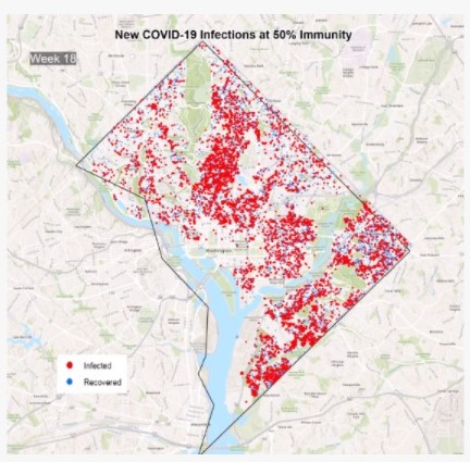
Epistemix Inc. can provide three scenarios showing future COVID-19 infections over time for any location within the United States. This is provided as three feature layers with 30%, 50%, and 70% of the population immune to the disease due either to vaccination or prior infection. The number of infections evolve over an 18-week period to illustrate how the disease spreads at different levels of immunity and demonstrates the importance of vaccinations.
Generated by our leading COVID-19 model, this data provides the scientific basis for powerful, community-specific visualizations and communications assets that health officials can use to drive vaccine uptake. For example, in this video, we contrast the spread of COVID-19 in the Washington, D.C area when the population is 50% vs. 70% immune.
