
Geonet : okt 6, 2021 08:41 PM : Project
To understand and mitigate the challenges caused by potential extreme events related to climate change, the Massachusetts Army National Guard (MA ARNG) initiated one of the defense industry’s first and most comprehensive climate change vulnerability assessments at Camp Edwards in Massachusetts. The effort identified at-risk infrastructure using a state-of-the-art, GIS-based, sea level rise and storm surge inundation model. The GIS model, developed by Kleinfelder based on the methodology used by the National Oceanic and Atmospheric Administration (NOAA) Coastal Services Center to map sea level rise inundation, was approved by MA ARNG. It was used to develop a quantitative and qualitative climate risk matrix from which the Guard is able to prioritize planning areas and prepare adaptation and resiliency plans.
The 22,000-acre Camp Edwards National Guard Base, commonly known as the Massachusetts Military Reservation (MMR), is located on Upper Cape Cod in Barnstable County, a low-lying, coastal peninsula with a fragile connection to the mainland. Sea level rise and storm surge are a primary concern to this area. MA ARNG contracted Kleinfelder, an architecture, engineering, and science consulting firm headquartered in Riverside, California, to conduct a climate change coastal flooding vulnerability assessment and prioritize adaptation solutions to these impacts on MMR infrastructure, training, and operations.
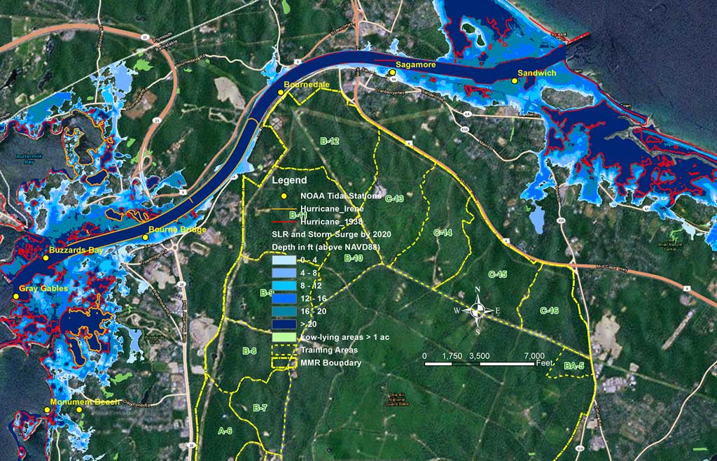 The GIS model includes both current and predicted data. High-resolution digital elevation models (DEMs) built from lidar terrain data with high vertical accuracy and tidal elevation data from the NOAA tidal gage stations surrounding the base provided a basis for mapping existing topography and tidal surface conditions. The team used the Highest Astronomical Tide (HAT) datum, which represents the highest predicted astronomical tide expected to occur at a specific tide station over the National Tidal Datum Epoch. [The NTDE is a specific 19-year period used by NOAA’s National Ocean Service as the official time period during which tide observations are taken and reduced to obtain mean values.]
The GIS model also incorporates the predicted sea level rise values for 2020 and 2060. The predicted tidal surface elevation for these future periods is a combination of present tidal elevation and projected sea level rise values as a result of climate change impacts. For the Base assessment, the team used predicted storm surge depths based on a worst-case Category 3 hurricane as predicted by the US National Weather Service’s Sea, Lake, and Overland Surges from Hurricanes (SLOSH) model to determine the projected water surface elevation at MMR.
The potential impacts of temperature and precipitation on MMR as a result of climate change were based on 2011 Massachusetts Climate Change Adaptation Report projections. [This report describes the findings of a state advisory board regarding the development and implementation of strategies that would allow Massachusetts to better adapt to climate change.]