GIS and BIM Provide Life Cycle Support for University’s Assets
OSU was originally founded in 1870 as the Ohio Agricultural and Mechanical College. The university’s name was changed eight years later when it graduated its first class of six students.
Today, OSU’s original Columbus campus enrolls nearly 60,000 students. In addition, OSU has six regional campuses throughout the state, where more than 6,000 students study. OSU’s multicampus facilities encompass 1,283 buildings that occupy about 16,000 acres (or 65 square kilometers) with infrastructure that rivals that of a small city.
OSU’s Facilities Information and Technology Services (FITS) department is a longtime user of AutoCAD and has implemented EvolveFM for space management and Revit for its building data. In 2013, the department decided to standardize on the ArcGIS platform for all its geospatial data
FITS originally set up a GIS advisory council to help define the university’s GIS needs and create a wish list of geospatial datasets and necessary field data collection. “We wanted to serve the entire campus and prevent isolated or redundant implementations,” said Kruger. “So it was decided to implement an ArcGIS site license to allow access to the platform throughout the entire campus network.”
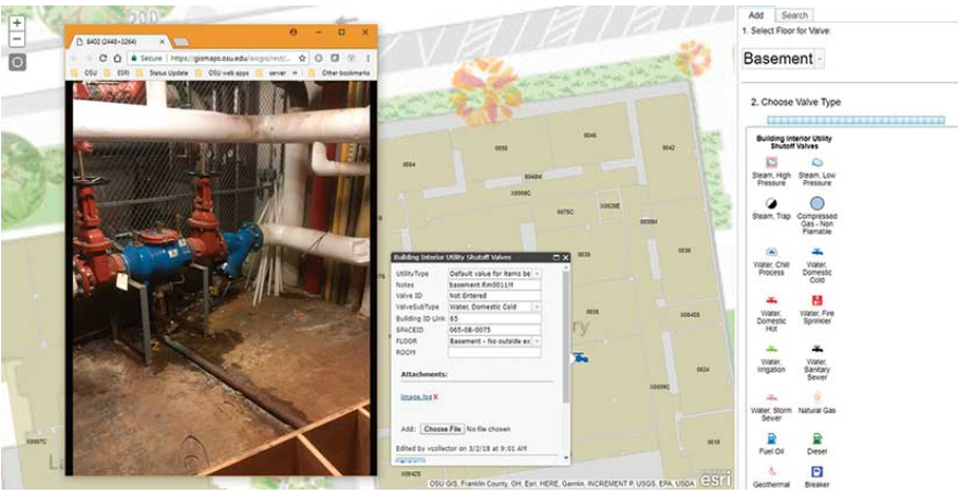
The university’s software stack includes ArcGIS Enterprise, ArcGIS Pro, Esri CityEngine, ArcGIS Online, ArcGIS Hub, and ArcMap,. AutoCAD and Revit from AutoDesk are used to create 2D drawings and 3D models. FME from Safe Software is used for data conversion. EvolveFM from CAFM Resources is used to extract floor plans from the AutoCAD or Revit 2D DWF files, which are georeferenced for use in ArcGIS
Previously, data was either uncollected or siloed away from those who need it. Using ArcGIS and other systems to collect and house data presents opportunities that will enhance the way OSU plans and operates its physical infrastructure. A system that gives operations staff members access to all the data they need from one source to do their jobs can potentially bring great efficiencies to their work.
“Our goal is to make these robust facilities data available across our entire campus through user-friendly systems,” concluded Kruger. “Our team exists to support decision-making across the life cycle of our building and infrastructure assets. We will do this by ensuring all decision-makers have access to the data they need, when they need it, and in an easy-to-use format. Having access to more data from the construction process aids in our ability to maintain our facilities long term